
1952 Map of Cape Mendenhall D-6
USGS Topo · Published 1958About this map
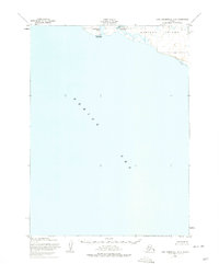
Nunivak Island meets the Bering Sea along this coastal stretch of the Alaska Territory, surveyed shortly after the Second World War. The shoreline is characterized by seasonal habitation sites and small watercourses, including the Kiyakyaliksamiut River and the sheltered waters of Dahloongamiut Lagoon. These landmarks reflect the subsistence patterns of the region, where coastal camps provided access to marine resources during the warmer months. The presence of Dahloongamiut (Summer Camp) and Kiyakyaliksamiut (Summer Camp) documents specific locations used for these traditional seasonal activities. To the east, a long Sand Beach borders the southern edge of the island, highlighting the transition from the rugged interior terrain to the open sea.
Find a feature on this map
7 named features on this map. Tap any name to fly to it.
Don’t see what you’re looking for? This feature index may not catch every label — zoom into the map to look around manually.
Map Details
Editions of this 1952 Cape Mendenhall D-6 Map
2 editions found
Other maps of this area

1951 · Cape Mendenhall
USGS Topo · 1:250,000

1951 · Nunivak Island
USGS Topo · 1:250,000

1952 · Nunivak Island A-7
USGS Topo · 1:63,360

1952 · Cape Mendenhall
USGS Topo · 1:250,000

1952 · Nunivak Island A-6
USGS Topo · 1:63,360

1952 · Nunivak Island A-5
USGS Topo · 1:63,360
1952 · Cape Mendenhall D-5
USGS Topo · 1:63,360

1954 · Nunivak Island
USGS Topo · 1:250,000

1958 · Nunivak Island
USGS Topo · 1:250,000

1964 · Nunivak Island
USGS Topo · 1:250,000