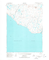
1952 Map of Cape Mendenhall D-5
USGS Topo · Published 1977About this map
Nunivak Island is characterized by a landscape of coastal dunes and complex hydrology within the Nunivak National Wildlife Refuge. The map details the southwest coast along the Bering Sea, where the Chakwakamiut River meets the shore at the seasonal settlement of Chakwakamiut (Summer Camp). The inland terrain is marked by prominent elevations such as Jayalik Hill and Binat-Ingrat Hill, interspersed with countless small lakes and the winding Jayalik River. To the east, the mouth of the Binajoakamiut R lies near Binajoakamiut (Aband), suggesting a shift in local habitation patterns. This 1952 survey, which was not field-checked, provides a record of the island's natural drainage and coastal features before late-twentieth-century revisions, including the expansive Boulder Beach and the shifting Dunes of the shoreline.
Find a feature on this map
13 named features on this map. Tap any name to fly to it.
Don’t see what you’re looking for? This feature index may not catch every label — zoom into the map to look around manually.
Map Details
Editions of this 1952 Cape Mendenhall D-5 Map
3 editions found
Other maps of this area

1951 · Cape Mendenhall
USGS Topo · 1:250,000

1951 · Nunivak Island
USGS Topo · 1:250,000

1952 · Cape Mendenhall D-4
USGS Topo · 1:63,360

1952 · Nunivak Island A-4
USGS Topo · 1:63,360

1952 · Cape Mendenhall
USGS Topo · 1:250,000

1952 · Cape Mendenhall D-6
USGS Topo · 1:63,360

1952 · Nunivak Island A-6
USGS Topo · 1:63,360

1952 · Nunivak Island A-5
USGS Topo · 1:63,360
1952 · Cape Mendenhall D-5
USGS Topo · 1:63,360

1954 · Nunivak Island
USGS Topo · 1:250,000