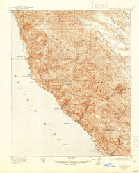
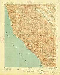
1921 Map of Cape San Martin
USGS Topo · Published 1944About this map
Mining and ranching activity defines this stretch of the Santa Lucia Range along the Pacific coast during the early twentieth century. The map details a landscape of high ridges and deep canyons within the Santa Barbara National Forest, where small-scale operations like the Melville Mine, Buolimo Mine, and Gorda Mine sought mineral wealth in the mountains overlooking Cape San Martin. These industrial sites are interspersed with pioneer holdings such as the Old Cruikshank Ranch and Krenkel's Ranch, illustrating the remote settlement patterns of the Big Sur region before modern accessibility.
Find a feature on this map
60 named features on this map. Tap any name to fly to it.
Don’t see what you’re looking for? This feature index may not catch every label — zoom into the map to look around manually.
Map Details
Editions of this 1921 Cape San Martin Map
6 editions found
Other maps of this area

1919 · King City
USGS Topo · 1:62,500

1919 · Junipero Serra
USGS Topo · 1:62,500

1919 · Bryson
USGS Topo · 1:62,500

1919 · Piedras Blancas
USGS Topo · 1:62,500

1919 · San Simeon
USGS Topo · 1:62,500

1921 · Cape San Martin
USGS Topo · 1:62,500

1921 · Lucia
USGS Topo · 1:62,500

1927 · Piedras Blancas
USGS Topo · 1:62,500

1937 · San Simeon
USGS Topo · 1:62,500

1939 · King City
USGS Topo · 1:62,500