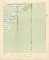
1919 Map of Capers Island
USGS Topo · Published 1919About this map
Videl Landing serves as a lone point of human infrastructure on this tidal landscape, marking the northern edge of Capers Island just before it meets Santee Pass. Surveyed during the final months of the First World War, this map documents the intricate barrier island systems of Charleston County before modern development transformed the shoreline. The intricate network of tidal waterways, including Copahee Sound and Bullyard Sound, reveals a complex environment of marshes and mudflats defined by the shifting currents of Capers Inlet and Dewees Inlet. Further south, the northern tip of the Isle of Palms is shown with its interior Alligator Pond, illustrating the natural state of these islands at a time when they were accessible primarily by water via routes like Seven Reaches and Morgan Cr.
Find a feature on this map
18 named features on this map. Tap any name to fly to it.
Don’t see what you’re looking for? This feature index may not catch every label — zoom into the map to look around manually.
Map Details
Editions of this 1919 Capers Island Map
2 editions found
Other maps of this area

1919 · The Jetties
USGS Topo · 1:21,120

1919 · Capers Island
USGS Topo · 1:21,120

1919 · Wando
USGS Topo · 1:21,120

1919 · Fort Moultrie
USGS Topo · 1:21,120

1919 · Bulls Island
USGS Topo · 1:21,120

1919 · Sewee Bay
USGS Topo · 1:21,120

1943 · Capers Island
USGS Topo · 1:24,000

1943 · Fort Moultrie
USGS Topo · 1:24,000

1943 · Wando
USGS Topo · 1:24,000

1943 · Sewee Bay
USGS Topo · 1:24,000