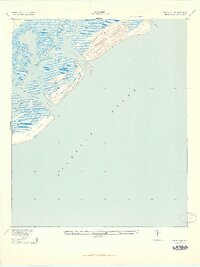
1943 Map of Capers Island
USGS Topo · Published 1943About this map
The salt marshes and sea islands of Charleston County are depicted here in the early 1940s, based on Army Map Service revisions of earlier surveys. This coastal landscape is dominated by the sprawling expanse of Capers Island and Dewees Island, separated from the mainland and each other by a complex network of tidal waterways. The map illustrates the natural state of the barrier islands before significant modern development, showing the shifting sands of Capers Inlet and Price Inlet. On the mainland side of the sounds, Vidal Landing provides a rare point of named infrastructure among the winding channels of Whiteside Creek and Santee Pass. Further south, the northeastern tip of the Isle of Palms is visible, transitioning from the open Atlantic Ocean into the sheltered waters of Bullyard Sound. The intricate detailing of the marsh drainage, including Seven Reaches and Morgan Cr, reveals the fluid nature of this lowcountry environment.
Find a feature on this map
16 named features on this map. Tap any name to fly to it.
Don’t see what you’re looking for? This feature index may not catch every label — zoom into the map to look around manually.
Map Details
Editions of this 1943 Capers Island Map
2 editions found
Other maps of this area

1919 · The Jetties
USGS Topo · 1:21,120

1919 · Capers Island
USGS Topo · 1:21,120

1919 · Wando
USGS Topo · 1:21,120

1919 · Fort Moultrie
USGS Topo · 1:21,120

1919 · Bulls Island
USGS Topo · 1:21,120

1919 · Sewee Bay
USGS Topo · 1:21,120

1943 · Capers Island
USGS Topo · 1:24,000

1943 · Fort Moultrie
USGS Topo · 1:24,000

1943 · Wando
USGS Topo · 1:24,000

1943 · Sewee Bay
USGS Topo · 1:24,000