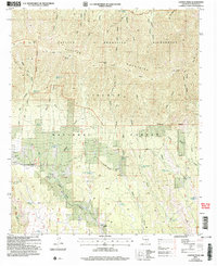
2004 Map of Capitan Peak
USGS Topo · Published 2006About this map
Capitan Peak stands as the primary landmark in this high-altitude region of the Lincoln National Forest, where steep canyons and narrow ridges define the landscape. This 2004 revision, based on imagery from the turn of the millennium, illustrates a network of trails and springs essential for movement and livestock in the arid environment. Routes like the Peppin Trail and Summit Trail traverse the Capitan Mountains Wilderness, connecting isolated water sources such as Seven Cabins Spring and Figure Seven Spring. The southern portion of the quadrangle shows the transition from the high peaks toward the lower drainages of Chavez Creek, where the presence of the McDaniel Ranch and numerous stock tanks like Ellis Canyon Tank point to the enduring ranching history of the area.
Find a feature on this map
52 named features on this map. Tap any name to fly to it.
Don’t see what you’re looking for? This feature index may not catch every label — zoom into the map to look around manually.
Map Details
Editions of this 2004 Capitan Peak Map
This is the sole edition of this map. No revisions or reprints were ever made.
Other maps of this area

1935 · Capitan Mountains
USGS Topo · 1:48,000

1936 · Arabela
USGS Topo · 1:48,000

1940 · Capitan Mountains
USGS Topo · 1:62,500

1942 · Arabela
USGS Topo · 1:62,500

1955 · Roswell
USGS Topo · 1:250,000

1958 · Roswell
USGS Topo · 1:250,000

1961 · Lincoln
USGS Topo · 1:62,500

1961 · Tinnie
USGS Topo · 1:62,500

1962 · Roswell
USGS Topo · 1:250,000
1981 · Capitan Pass
USGS Topo · 1:24,000