
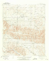
1935 Map of Capitan Mountains
USGS Topo · Published 1935About this map
The U S Marine Hospital Reservation stands as a significant landmark in the southwestern portion of this survey, set against the dramatic elevation of the Capitan Mountains. Mapped during the mid-1930s, the landscape reveals a sparse but established ranching economy, with family names marking the terrain at Merchant Ranch, Shoemaker Ranch, and Koprian Ranch. Education in this rural stretch of Lincoln National Forest was centered at the Richardson School and Baca Sch.
Find a feature on this map
49 named features on this map. Tap any name to fly to it.
Don’t see what you’re looking for? This feature index may not catch every label — zoom into the map to look around manually.
Map Details
Editions of this 1935 Capitan Mountains Map
2 editions found
Other maps of this area

1934 · Capitan
USGS Topo · 1:48,000

1936 · Arabela
USGS Topo · 1:48,000

1937 · Capitan
USGS Topo · 1:62,500

1940 · Capitan Mountains
USGS Topo · 1:62,500

1942 · Arabela
USGS Topo · 1:62,500

1955 · Roswell
USGS Topo · 1:250,000

1958 · Roswell
USGS Topo · 1:250,000

1961 · Lincoln
USGS Topo · 1:62,500

1961 · Tinnie
USGS Topo · 1:62,500

1962 · Roswell
USGS Topo · 1:250,000