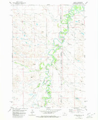
1980 Map of Capitol
USGS Topo · Published 1980About this map
The Little Missouri River snakes through this high plains landscape on the border of Montana and South Dakota, creating a series of dramatic meanders and landforms. The small community of Capitol serves as a focal point, featuring the Capitol Sch and Capitol Cem positioned near the river's path. The topography is defined by the river's erosive power, which has carved out named features such as Lupe Bend, Harring Bend, and The Island. Away from the water, the terrain rises into prominent landmarks like Indian Butte and Mud Butte. The area’s ranching character is evident through the presence of several Landing Strips and local water management features like the Davis Reservoir. Dozens of ephemeral drainages, including Forty-eight Mile Creek and Sand Creek, feed into the primary river valley, illustrating the complex drainage patterns of the region.
Find a feature on this map
36 named features on this map. Tap any name to fly to it.
Don’t see what you’re looking for? This feature index may not catch every label — zoom into the map to look around manually.
Map Details
Editions of this 1980 Capitol Map
2 editions found
Other maps of this area

1935 · Harding
USGS Topo · 1:125,000

1935 · Buffalo
USGS Topo · 1:125,000

1954 · Lemmon
USGS Topo · 1:250,000

1954 · Ekalaka
USGS Topo · 1:250,000

1956 · Ekalaka
USGS Topo · 1:250,000

1957 · Lemmon
USGS Topo · 1:250,000

1958 · Ekalaka
USGS Topo · 1:250,000

1965 · Ekalaka
USGS Topo · 1:250,000
1977 · Camp Crook
USGS Topo · 1:24,000
1978 · J K Butte
USGS Topo · 1:24,000