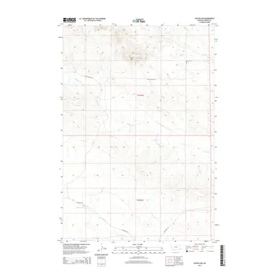
2014 Map of Capitol NW
USGS Topo · Published 2014About this map
Sheep Mtn dominates the high ground in this section of Carter County, anchoring a landscape defined by an intricate network of seasonal drainage and prairie creeks. The map captures the area's rural character as it appeared in the early 21st century, where large-scale land divisions of t4s r61e and t5s r61e provide the primary framework for navigation. Water sources like Hackberry Cr and Cottonwood Cr wind through the terrain, indicating the vital riparian corridors that have supported local ranching for generations. Movement through this corner of Montana is facilitated by legacy routes including Sheep Mountain Rd and Bickerdyke Rd, which follow the natural contours of the land rather than a strict grid.
Find a feature on this map
9 named features on this map. Tap any name to fly to it.
Don’t see what you’re looking for? This feature index may not catch every label — zoom into the map to look around manually.
Map Details
Editions of this 2014 Capitol NW Map
This is the sole edition of this map. No revisions or reprints were ever made.
Other maps of this area

1954 · Ekalaka
USGS Topo · 1:250,000

1956 · Ekalaka
USGS Topo · 1:250,000

1958 · Ekalaka
USGS Topo · 1:250,000

1965 · Ekalaka
USGS Topo · 1:250,000
1980 · Capitol Rock
USGS Topo · 1:24,000

1980 · Cactus Creek West
USGS Topo · 1:24,000

1980 · Finger Buttes East
USGS Topo · 1:24,000

1980 · Belltower Butte
USGS Topo · 1:24,000
1980 · Capitol NW
USGS Topo · 1:24,000
1980 · Lone Tree Creek
USGS Topo · 1:24,000