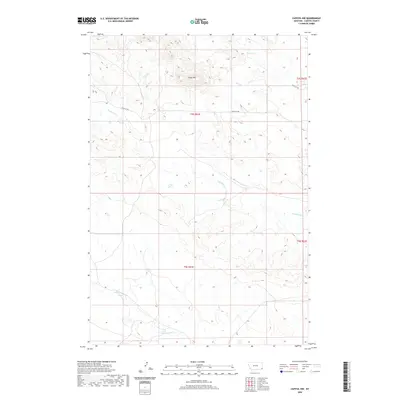
2020 Map of Capitol NW
USGS Topo · Published 2020About this map
Sheep Mtn rises above a landscape defined by an intricate network of seasonal drainage in this portion of Carter County. The terrain is marked by the meandering paths of Hackberry Cr, Bull Cr, and Sand Cr in the northern sections, while Cottonwood Cr winds through the southern reaches. This modern topographical survey illustrates a sparsely populated region where human activity is primarily indicated by the solitary Sheep Mt Rd, which traverses the high ground. The map details the Public Land Survey System grid across townships T4S R61E and T5S R61E, showing the intersection of natural watercourses with the geometric boundaries of western land management. The sparse infrastructure and concentration of named creeks suggest a reliance on these natural landmarks for navigation and local ranching operations in this part of Montana.
Find a feature on this map
10 named features on this map. Tap any name to fly to it.
Don’t see what you’re looking for? This feature index may not catch every label — zoom into the map to look around manually.
Map Details
Editions of this 2020 Capitol NW Map
This is the sole edition of this map. No revisions or reprints were ever made.
Other maps of this area

1954 · Ekalaka
USGS Topo · 1:250,000

1956 · Ekalaka
USGS Topo · 1:250,000

1958 · Ekalaka
USGS Topo · 1:250,000

1965 · Ekalaka
USGS Topo · 1:250,000
1980 · Capitol Rock
USGS Topo · 1:24,000

1980 · Cactus Creek West
USGS Topo · 1:24,000

1980 · Finger Buttes East
USGS Topo · 1:24,000

1980 · Belltower Butte
USGS Topo · 1:24,000
1980 · Capitol NW
USGS Topo · 1:24,000
1980 · Lone Tree Creek
USGS Topo · 1:24,000