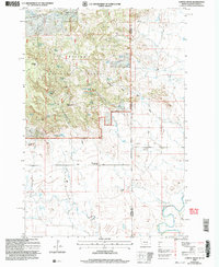
2005 Map of Capitol Rock
USGS Topo · Published 2007About this map
Capitol Rock stands as a prominent landmark within the expansive timberlands of Custer National Forest, marking a landscape where the high plains of the Montana-South Dakota border transition into the Long Pines region. This 2005 revision highlights a sparse ranching economy, where family-named holdings like Schell-Long Pines Ranch and B Padden Ranch are anchored by vital water sources such as Wickham Spring No 1 and Coyote Spring. The infrastructure reflects the remote nature of the area, centered on the Plainview Sch (Abandoned) along Tie Creek Road. The southeastern corner of the map reveals the winding course of the Little Missouri River, which drains the various draws and reservoirs like West Lindsay Reservoir that sustain livestock in this arid borderland.
Find a feature on this map
39 named features on this map. Tap any name to fly to it.
Don’t see what you’re looking for? This feature index may not catch every label — zoom into the map to look around manually.
Map Details
Editions of this 2005 Capitol Rock Map
This is the sole edition of this map. No revisions or reprints were ever made.
Other maps of this area

1935 · Harding
USGS Topo · 1:125,000

1935 · Buffalo
USGS Topo · 1:125,000

1954 · Lemmon
USGS Topo · 1:250,000

1954 · Ekalaka
USGS Topo · 1:250,000

1956 · Ekalaka
USGS Topo · 1:250,000

1957 · Lemmon
USGS Topo · 1:250,000

1958 · Ekalaka
USGS Topo · 1:250,000

1965 · Ekalaka
USGS Topo · 1:250,000

1974 · Caroline Butte
USGS Topo · 1:24,000
1977 · Camp Crook
USGS Topo · 1:24,000