
1912 Map of Capitola
USGS Topo · Published 1955About this map
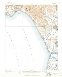
Soquel Cove curves along the Monterey Bay shoreline, anchoring a landscape defined by expansive Spanish land grant boundaries and a burgeoning coastal economy. Inland from Capitola, the terrain rises into the Santa Cruz Mountains, where the intricate drainage of Soquel Creek, Aptos Creek, and Trout Gulch carved the canyons that guided early settlement. The map illustrates the dominance of the Southern Pacific railroad line as it skirts the coast through Aptos and Manresa, facilitating the transport of agricultural goods from the fertile lowlands near Watsonville.
Find a feature on this map
68 named features on this map. Tap any name to fly to it.
Don’t see what you’re looking for? This feature index may not catch every label — zoom into the map to look around manually.
Map Details
Editions of this 1912 Capitola Map
2 editions found
Other maps of this area

1902 · Santa Cruz
USGS Topo · 1:125,000

1910 · Salinas
USGS Topo · 1:31,680

1912 · Salinas
USGS Topo · 1:62,500

1913 · Monterey
USGS Topo · 1:62,500

1914 · Capitola
USGS Topo · 1:62,500

1915 · San Juan Bautista
USGS Topo · 1:48,000

1916 · New Almaden
USGS Topo · 1:48,000

1917 · Morgan Hill
USGS Topo · 1:62,500

1917 · San Juan Bautista
USGS Topo · 1:62,500

1919 · New Almaden
USGS Topo · 1:62,500