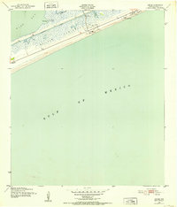
1943 Map of Caplen
USGS Topo · Published 1953About this map
Bolivar Peninsula forms a narrow, salt-scrubbed barrier between the Gulf of Mexico and the marshy expanses of East Bay during the early 1940s. This period captures a landscape defined by both maritime security and the emerging petroleum industry, as evidenced by the Coast Guard Station near Caplen and scattered Oil Wells and Oil Tanks further west. The Intracoastal Waterway cuts through the northern reach of the peninsula, facilitating coastal trade while bypassing the natural winding paths of Yates Bayou and Big Pasture Bayou. Small clusters of human activity are centered at the settlements of Patton and Caplen, where a local Cem and a lone Windmill provide rare landmarks in an otherwise flat terrain dominated by Crab Lake and Yates Cove. The map reflects a moment when industrial infrastructure began to punctuate this traditional coastal environment.
Find a feature on this map
20 named features on this map. Tap any name to fly to it.
Don’t see what you’re looking for? This feature index may not catch every label — zoom into the map to look around manually.
Map Details
Editions of this 1943 Caplen Map
This is the sole edition of this map. No revisions or reprints were ever made.
Other maps of this area

1931 · Flake
USGS Topo · 1:24,000

1931 · High Island
USGS Topo · 1:24,000

1931 · Frozen Point
USGS Topo · 1:24,000

1933 · Frozen Point
USGS Topo · 1:31,680

1933 · Caplen
USGS Topo · 1:31,680

1933 · The Jetties
USGS Topo · 1:31,680

1933 · Whites Lake
USGS Topo · 1:31,680

1933 · Flake
USGS Topo · 1:31,680

1943 · High Island
USGS Topo · 1:31,680
1943 · Flake
USGS Topo · 1:25,000