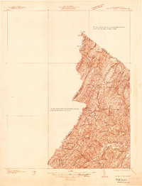
1937 Map of Capon Bridge
USGS Topo · Published 1937About this map
The state line between West Virginia and Virginia bisects a landscape defined by the parallel ridges of Capon Mountain, Timber Ridge, and Bear Garden Mountain. This advance sheet shows the eastern edge of Hampshire County and the northern reach of Frederick County during the late 1930s, where rural life centered on crossroads settlements and a network of small community institutions. Local commerce is anchored by Reynolds Store and the town of Gore, while the region's spiritual and educational foundations are visible in the numerous country churches like Wesley Chapel, Salem Ch, and Nelson Chapel, alongside the Gainesboro Sch. Transportation follows the natural grain of the valley, with the Northwestern Turnpike No 50 and the Winchester and Western Highway cutting through gaps like Catlett Gap. The map also captures several family-named landmarks and water features, including Isaacs Creek and Yeiders Run, providing a detailed view of the area's pre-war geography.
Find a feature on this map
50 named features on this map. Tap any name to fly to it.
Don’t see what you’re looking for? This feature index may not catch every label — zoom into the map to look around manually.
Map Details
Editions of this 1937 Capon Bridge Map
4 editions found

Other maps of this area

1891 · Romney
USGS Topo · 1:125,000

1894 · Winchester
USGS Topo · 1:125,000

1898 · Paw Paw
USGS Topo · 1:62,500

1899 · Flintstone
USGS Topo · 1:62,500

1899 · Hancock
USGS Topo · 1:62,500

1900 · Pawpaw
USGS Topo · 1:62,500

1900 · Flintstone
USGS Topo · 1:62,500

1901 · Hancock
USGS Topo · 1:62,500

1910 · Paw Paw
USGS Topo · 1:62,500

1914 · Gerrardstown
USGS Topo · 1:48,000