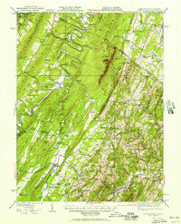
1937 Map of Capon Bridge
USGS Topo · Published 1957About this map
The Cacapon River meanders dramatically through the narrow valleys of West Virginia and Virginia, defining the complex landscape of the northern Shenandoah Valley region. During the mid-1930s, the river’s serpentine path dominated the terrain, flanked by massive ridges like Spring Gap Mountain and Sideling Hill. The settlement at Capon Bridge serves as a central hub where the historic Northwestern Turnpike crosses the water, while the Winchester and Western Railroad snakes through the eastern corridor near Gainesboro. This survey reveals a dense network of local landmarks, including the geological curiosity of Ice Mountain and dozens of rural institutions such as the Furnace School and Mt Olive Church. The distribution of Critton School, Victory School, and Woodrow School illustrates the era's decentralized education system, where small schoolhouses were built within walking distance of scattered mountain homesteads.
Find a feature on this map
111 named features on this map. Tap any name to fly to it.
Don’t see what you’re looking for? This feature index may not catch every label — zoom into the map to look around manually.
Map Details
Editions of this 1937 Capon Bridge Map
4 editions found

Other maps of this area

1891 · Romney
USGS Topo · 1:125,000

1894 · Winchester
USGS Topo · 1:125,000

1898 · Paw Paw
USGS Topo · 1:62,500

1899 · Flintstone
USGS Topo · 1:62,500

1899 · Hancock
USGS Topo · 1:62,500

1900 · Pawpaw
USGS Topo · 1:62,500

1900 · Flintstone
USGS Topo · 1:62,500

1901 · Hancock
USGS Topo · 1:62,500

1910 · Paw Paw
USGS Topo · 1:62,500

1914 · Gerrardstown
USGS Topo · 1:48,000