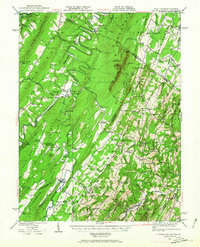
1937 Map of Capon Bridge
USGS Topo · Published 1963About this map
The Cacapon River winds through a series of steep ridges including Gore Mountain and Sideling Hill in this 1930s survey of the West Virginia and Virginia borderlands. The settlement of Capon Bridge serves as a primary crossing point where the Northwestern Turnpike meets the river, while the Winchester and Western RR skirts the eastern edge of the quadrangle near Gainesboro. This landscape is deeply etched with rural social structures, evidenced by numerous mountainside schools like Furnace School and Pinoak School, alongside family-named landmarks such as Darbys Nose and Slanes Knob. The map documents the intricate drainage network of the Ridge-and-Valley province, where small communities like Bloomery and Whitacre are tied to the runs and hollows of the Timber Ridge area before mid-century modernizations changed the character of these border counties.
Find a feature on this map
122 named features on this map. Tap any name to fly to it.
Don’t see what you’re looking for? This feature index may not catch every label — zoom into the map to look around manually.
Map Details
Editions of this 1937 Capon Bridge Map
4 editions found

Other maps of this area

1891 · Romney
USGS Topo · 1:125,000

1894 · Winchester
USGS Topo · 1:125,000

1898 · Paw Paw
USGS Topo · 1:62,500

1899 · Flintstone
USGS Topo · 1:62,500

1899 · Hancock
USGS Topo · 1:62,500

1900 · Pawpaw
USGS Topo · 1:62,500

1900 · Flintstone
USGS Topo · 1:62,500

1901 · Hancock
USGS Topo · 1:62,500

1910 · Paw Paw
USGS Topo · 1:62,500

1914 · Gerrardstown
USGS Topo · 1:48,000