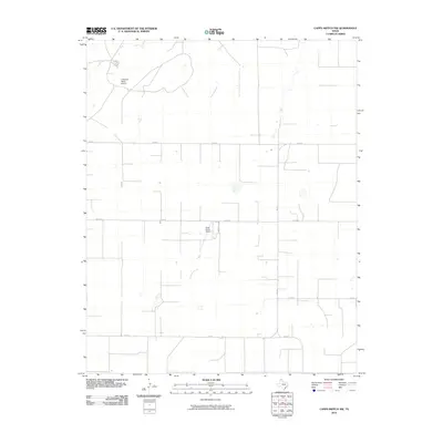
2010 Map of Capps Switch NW
USGS Topo · Published 2010About this map
Coldwater Ranch Airport and Cluck Ranch Airport stand as primary landmarks in this sparsely populated region of the Texas Panhandle. The landscape is defined by the high plains of Sherman County, where the north-south channel of Coldwater Creek provides a rare natural break in the otherwise flat topography. The map illustrates a strictly organized grid of agricultural and ranching corridors, with FM 1573 and FM 1060 serving as the principal transit routes between sprawling ranch properties. The distribution of ranch airports alongside rural county roads like Co Rd U and Co Rd W reflects the large-scale land management common to this area, where aviation is an essential tool for navigating and monitoring the expansive High Plains territory during the early 21st century.
Find a feature on this map
8 named features on this map. Tap any name to fly to it.
Don’t see what you’re looking for? This feature index may not catch every label — zoom into the map to look around manually.
Map Details
Editions of this 2010 Capps Switch NW Map
This is the sole edition of this map. No revisions or reprints were ever made.
Other maps of this area

1954 · Perryton
USGS Topo · 1:250,000

1958 · Perryton
USGS Topo · 1:250,000

1972 · Capps Switch
USGS Topo · 1:24,000

1972 · Sunray
USGS Topo · 1:24,000
1974 · Capps Switch SE
USGS Topo · 1:24,000

1974 · Stevens SE
USGS Topo · 1:24,000

1974 · Sunray 1 SW
USGS Topo · 1:24,000

1974 · Sunray 1 SE
USGS Topo · 1:24,000

1974 · Capps Switch NW
USGS Topo · 1:24,000
1974 · Pleasure Pond
USGS Topo · 1:24,000