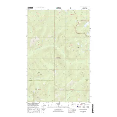
2017 Map of Captain Point
USGS Topo · Published 2017About this map
The Pacific Crest National Scenic Trail traverses the high ridges of the Cascade Range in this high-elevation region where the Wenatchee National Forest meets the Snoqualmie National Forest. Centered on the rugged convergence of King, Snohomish, and Chelan counties, the terrain is defined by a dense network of glacial basins and peaks. Significant landmarks include Captain Point, Grizzly Peak, and Valhalla Mtn, which tower over numerous alpine water bodies such as Peach Lake, Grizzly Lake, and the remote Mount Fernow Potholes. The drainage system is dominated by the Rapid River and its North Fork, alongside the headwaters of Johnson Creek and Kelley Creek. This survey details a landscape largely inaccessible by road, with only the Nat For Dev Rd 6530 penetrating the southwestern slopes near Sunrise Mtn, leaving the vast majority of the territory to the paths of through-hikers and the natural courses of the mountain divides.
Find a feature on this map
45 named features on this map. Tap any name to fly to it.
Don’t see what you’re looking for? This feature index may not catch every label — zoom into the map to look around manually.
Map Details
Editions of this 2017 Captain Point Map
This is the sole edition of this map. No revisions or reprints were ever made.
Other maps of this area

1902 · Skykomish
USGS Topo · 1:125,000

1905 · Skykomish
USGS Topo · 1:125,000

1957 · Wenatchee
USGS Topo · 1:250,000

1965 · Captain Point
USGS Topo · 1:24,000

1965 · Evergreen Mtn
USGS Topo · 1:24,000

1965 · Stevens Pass
USGS Topo · 1:24,000

1965 · Skykomish
USGS Topo · 1:24,000

1965 · Poe Mountain
USGS Topo · 1:24,000
1965 · Bench Mark Mtn
USGS Topo · 1:24,000
1965 · Scenic
USGS Topo · 1:24,000