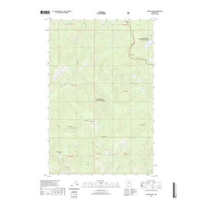
2020 Map of Captain Point
USGS Topo · Published 2020About this map
Captain Point stands as a central peak within this high-elevation wilderness, where the borders of the Snoqualmie National Forest and Wenatchee National Forest meet. The landscape is defined by its complex hydrology and dramatic relief, evidenced by the clustered Mount Fernow Potholes and numerous alpine basins containing Joan Lake, Scrabble Lake, and Bertha Lake. The drainage network of the Rapid River and its northern fork creates deep incisions through the terrain, separating prominent ridges such as Johnson Ridge from peaks like Scorpion Mtn and Valhalla Mtn.
Find a feature on this map
49 named features on this map. Tap any name to fly to it.
Don’t see what you’re looking for? This feature index may not catch every label — zoom into the map to look around manually.
Map Details
Editions of this 2020 Captain Point Map
This is the sole edition of this map. No revisions or reprints were ever made.
Other maps of this area

1902 · Skykomish
USGS Topo · 1:125,000

1905 · Skykomish
USGS Topo · 1:125,000

1957 · Wenatchee
USGS Topo · 1:250,000

1965 · Captain Point
USGS Topo · 1:24,000

1965 · Evergreen Mtn
USGS Topo · 1:24,000

1965 · Stevens Pass
USGS Topo · 1:24,000

1965 · Skykomish
USGS Topo · 1:24,000

1965 · Poe Mountain
USGS Topo · 1:24,000
1965 · Bench Mark Mtn
USGS Topo · 1:24,000
1965 · Scenic
USGS Topo · 1:24,000