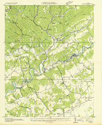
1934 Map of Carbo
USGS Topo · Published 1934About this map
Clinch River winds through the heart of this 1934 topographic survey, defining a landscape of narrow valleys and coal-bearing ridges in Russell County. The industrial footprint of the Clinchfield RR and the Norfolk and Western railroads is prominent, serving the local economy at sites like Dixie Beaver Coal Co and the settlement of Clinchfield. This era of public works and resource management is captured by the presence of Camp Dixie C C C and the U S G S Gaging Sta near Cleveland. Genealogy resources abound with numerous country churches like Springfield Ch and schools including Mill Creek Sch and Gravel Lick Sch. From the agricultural Red Oak Field to the distinct geology of Sinkhole Valley, the map provides a look at Southwestern Virginia's rural and industrial character between the world wars.
Find a feature on this map
74 named features on this map. Tap any name to fly to it.
Don’t see what you’re looking for? This feature index may not catch every label — zoom into the map to look around manually.
Map Details
Editions of this 1934 Carbo Map
This is the sole edition of this map. No revisions or reprints were ever made.
Other maps of this area

1886 · Grundy
USGS Topo · 1:125,000

1890 · Grundy
USGS Topo · 1:125,000

1892 · Grundy
USGS Topo · 1:125,000

1897 · Bristol
USGS Topo · 1:125,000

1902 · Bristol
USGS Topo · 1:125,000

1913 · Clintwood
USGS Topo · 1:62,500

1914 · Bucu
USGS Topo · 1:48,000

1915 · Clintwood
USGS Topo · 1:62,500

1916 · Bucu
USGS Topo · 1:62,500

1918 · Carterton
USGS Topo · 1:62,500