
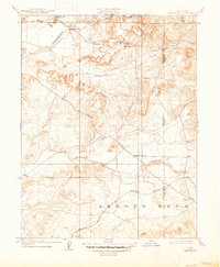
1909 Map of Carbondale
USGS Topo · Published 1909About this map
The Cosumnes River corridor in the northern reaches of the Central Valley defines this 1907 survey, showing the rural landscape where Sacramento and Amador counties meet. The presence of several distinct schoolhouses, including Stone House School, Michigan Bar School, Buckeye School, and Carbondale School, indicates a distributed community of ranching and early industrial families. The Southern Pacific railroad cuts through the southern terrain near the Arroyo Seco, connecting the settlement of Carbondale to the wider region. Historical landmarks like Alabama House and Bridge House serve as notable waypoints along the early thoroughfares, including Jackson Road. The map documents a period when small settlements like Michigan Bar and Liveoak were active hubs before the shifting economic tides of the early twentieth century altered the density of these rural California outposts.
Find a feature on this map
20 named features on this map. Tap any name to fly to it.
Don’t see what you’re looking for? This feature index may not catch every label — zoom into the map to look around manually.
Map Details
Editions of this 1909 Carbondale Map
2 editions found
Other maps of this area

1889 · Jackson
USGS Topo · 1:125,000

1891 · Sacramento
USGS Topo · 1:125,000

1891 · Placerville
USGS Topo · 1:125,000

1892 · Jackson
USGS Topo · 1:125,000

1892 · Sacramento
USGS Topo · 1:125,000

1892 · Placerville
USGS Topo · 1:125,000

1893 · Placerville
USGS Topo · 1:125,000

1893 · Sacramento
USGS Topo · 1:125,000

1894 · Lodi
USGS Topo · 1:125,000

1897 · Jackson
USGS Topo · 1:125,000