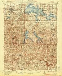
1922 Map of Carbondale
USGS Topo · Published 1943About this map
Carbondale serves as the focal point of this Southern Illinois landscape, positioned where the Illinois Central railroad lines intersect. In the early 1940s, the terrain was undergoing a massive transformation with the development of major water bodies like Crab Orchard Lake, Little Grassy Lake, and Devils Kitchen Lake, which dominate the central and eastern portions of the map. South of the city, the dramatic geology of the Shawnee Hills is represented by Giant City State Park and high points such as Tygart Knob and Buck Knob. The rural landscape is remarkably dense with 19th-century educational and religious foundations, including South County Line Church and over two dozen country schools like Covered Bridge School and Poplar Grove School, illustrating the tight-knit settlement patterns of Jackson, Williamson, and Union counties before post-war consolidation.
Find a feature on this map
80 named features on this map. Tap any name to fly to it.
Don’t see what you’re looking for? This feature index may not catch every label — zoom into the map to look around manually.
Map Details
Editions of this 1922 Carbondale Map
3 editions found
Other maps of this area

1909 · West Frankfort
USGS Topo · 1:62,500

1910 · Herrin
USGS Topo · 1:62,500

1910 · Murphysboro
USGS Topo · 1:62,500

1918 · Vienna
USGS Topo · 1:62,500

1919 · Vienna
USGS Topo · 1:62,500

1920 · Jonesboro
USGS Topo · 1:62,500

1920 · Dongola
USGS Topo · 1:62,500

1922 · Carbondale
USGS Topo · 1:62,500

1923 · Dongola
USGS Topo · 1:62,500

1923 · Jonesboro
USGS Topo · 1:62,500