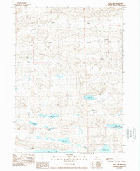
1989 Map of Card Lake
USGS Topo · Published 1989About this map
Ideal Valley and Survey Valley dominate this corner of the Nebraska Sandhills, where the landscape is defined by an intricate network of interdunal wetlands and lakes. Cattle ranching remains the primary human footprint, marked by scattered homesteads such as the Frye Ranch, Jamison Ranch, and Card Ranch. These operations are situated near vital water sources like Card Lake and Bos Lake, illustrating the essential relationship between the region's high water table and the livestock industry. In the southern portion of the survey, larger bodies of water including Red Mill Lake, Tony Lake, and Alkali Lake appear alongside Indian Lake, providing a clear picture of the hydrological patterns that have sustained these isolated ranching communities through the late twentieth century.
Find a feature on this map
19 named features on this map. Tap any name to fly to it.
Don’t see what you’re looking for? This feature index may not catch every label — zoom into the map to look around manually.
Map Details
Editions of this 1989 Card Lake Map
This is the sole edition of this map. No revisions or reprints were ever made.
Other maps of this area

1948 · Ashby
USGS Topo · 1:62,500

1948 · Bingham
USGS Topo · 1:62,500

1948 · Spade Ranch
USGS Topo · 1:62,500

1949 · Ashby
USGS Topo · 1:62,500

1949 · Turpin Lake
USGS Topo · 1:62,500

1950 · Spade Ranch
USGS Topo · 1:62,500

1950 · Bingham
USGS Topo · 1:62,500

1951 · Turpin Lake
USGS Topo · 1:62,500

1955 · Alliance
USGS Topo · 1:250,000

1957 · Alliance
USGS Topo · 1:250,000