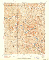
1928 Map of Cardareva
USGS Topo · Published 1950About this map
The Current River snakes through the center of this Ozark landscape, serving as the primary geographical axis for local life between the world wars. Following a 1925 survey by J.B. Leavitt, the map documents a remote region of Shannon Co and Carter Co defined by its deep hollows and high peaks like Thorny Mtn and Cardareva Mtn. The river crossings, including Williams Ford and Goose Bay Ford, were vital connections for small communities such as Exchange and Deslet. Education was highly localized, evidenced by the dense network of rural schoolhouses such as Whitehall School, Button School, and Paint Rock School. The presence of Paint Rock Bluff and Banker Cave highlights a terrain where natural landmarks served as both navigational aids and community fixtures.
Find a feature on this map
101 named features on this map. Tap any name to fly to it.
Don’t see what you’re looking for? This feature index may not catch every label — zoom into the map to look around manually.
Map Details
Editions of this 1928 Cardareva Map
2 editions found
Other maps of this area

1915 · Eminence
USGS Topo · 1:62,500

1917 · Eminence
USGS Topo · 1:62,500

1928 · Cardareva
USGS Topo · 1:62,500

1931 · Bandyville
USGS Topo · 1:48,000

1943 · Ellington
USGS Topo · 1:62,500

1943 · Lesterville
USGS Topo · 1:62,500

1944 · Van Buren
USGS Topo · 1:62,500

1944 · Birch Tree
USGS Topo · 1:62,500

1944 · Grandin
USGS Topo · 1:62,500

1944 · Corridon
USGS Topo · 1:62,500