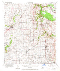
1957 Map of Carencro
USGS Topo · Published 1965About this map
Carencro and Grand Coteau anchor this 1950s survey of the Acadiana prairie, a landscape defined by an intricate network of slow-moving waterways and a growing energy sector. The topography is dominated by bayous such as Bayou Teche and Bayou Plaquemine Brule, which wind through the parishes alongside the Southern Pacific and Texas and Pacific railroads. The era’s industrial footprint is visible through numerous petroleum operations, including the Church Point Gas Field and the Cankton Oil and Gas Field. Rural life is centered around small settlements and institutions like the Sacred Heart Academy and Christ the King Sch. From the outskirts of Sunset down to Vatican, the map captures a transition between traditional agriculture and the burgeoning oil and gas economy that reshaped the Louisiana interior mid-century.
Find a feature on this map
65 named features on this map. Tap any name to fly to it.
Don’t see what you’re looking for? This feature index may not catch every label — zoom into the map to look around manually.
Map Details
Editions of this 1957 Carencro Map
2 editions found

Other maps of this area

1934 · Duson
USGS Topo · 1:31,680

1935 · Branch
USGS Topo · 1:31,680

1939 · Opelousas
USGS Topo · 1:62,500

1939 · St. Martinsville
USGS Topo · 1:62,500

1940 · Arnaudville
USGS Topo · 1:62,500

1946 · Lafayette
USGS Topo · 1:31,680

1946 · Rayne
USGS Topo · 1:31,680

1947 · Branch
USGS Topo · 1:31,680

1947 · Chataignier
USGS Topo · 1:31,680

1947 · Pitreville
USGS Topo · 1:31,680