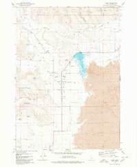
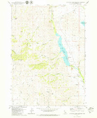
1979 Map of Carey
USGS Topo · Published 1980About this map
The agricultural and geological boundaries of Blaine County meet near Carey, where the southern edge of the Little Wood River valley hits an expanse of Lava flows. In the late 1970s, the irrigation infrastructure necessary for high-desert farming was well-established, evidenced by the West Canal, East Canal, and technical features like a Flume and Siphon. The local community is anchored by the High Sch, County Fairgrounds, and the Carey Cemetery, while the presence of Hot Springs Ranch and various thermal outlets like Spring (Hot) near Carey Lake point to the area's geothermal activity. North of town, the terrain transitions into deep cuts like Box Canyon and Phillips Canyon, illustrating the contrast between the fertile valley floor and the surrounding volcanic and mountainous highlands.
Find a feature on this map
35 named features on this map. Tap any name to fly to it.
Don’t see what you’re looking for? This feature index may not catch every label — zoom into the map to look around manually.
Map Details
Editions of this 1979 Carey Map
This is the sole edition of this map. No revisions or reprints were ever made.
Other maps of this area

1955 · Idaho Falls
USGS Topo · 1:250,000

1955 · Hailey
USGS Topo · 1:250,000

1958 · Idaho Falls
USGS Topo · 1:250,000

1959 · Hailey
USGS Topo · 1:250,000

1962 · Hailey
USGS Topo · 1:250,000

1978 · Craters Of The Moon
USGS Topo · 1:100,000
1979 · Paddelford Flat
USGS Topo · 1:24,000
1979 · Pagari Well
USGS Topo · 1:24,000
1979 · Wagon Butte
USGS Topo · 1:24,000
1979 · Little Wood River Reservoir
USGS Topo · 1:24,000