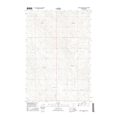
2017 Map of Carey-Malone School
USGS Topo · Published 2017About this map
The Carey-Malone School stands as a central landmark in this remote section of Custer County, situated near the intersection of several critical local thoroughfares including Foster Creek Rd and Basin Creek Rd. This landscape is defined by its complex drainage network, where numerous waterways like Haddow Cr, Coalbank Cr, and McFee Cr carve through the high plains. The topography reveals a sparsely settled region where cattle ranching and land management are facilitated by a sparse grid of gravel roads such as Ash Creek Rd. The convergence of Road Cr and other small tributaries underscores the importance of water management and access in this expansive Montana environment during the early 21st century.
Find a feature on this map
19 named features on this map. Tap any name to fly to it.
Don’t see what you’re looking for? This feature index may not catch every label — zoom into the map to look around manually.
Map Details
Editions of this 2017 Carey-Malone School Map
This is the sole edition of this map. No revisions or reprints were ever made.
Other maps of this area

1953 · Miles City
USGS Topo · 1:250,000

1954 · Ekalaka
USGS Topo · 1:250,000

1956 · Ekalaka
USGS Topo · 1:250,000

1957 · Miles City
USGS Topo · 1:250,000

1958 · Miles City
USGS Topo · 1:250,000

1958 · Ekalaka
USGS Topo · 1:250,000

1965 · Ekalaka
USGS Topo · 1:250,000

1969 · Beebe SW
USGS Topo · 1:24,000
1969 · Garland School
USGS Topo · 1:24,000
1969 · Jack Creek
USGS Topo · 1:24,000