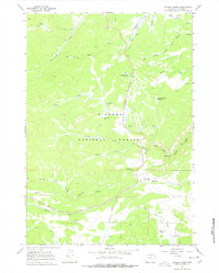
1967 Map of Caribou Creek
USGS Topo · Published 1978About this map
Bighorn National Forest dominates this landscape in Johnson County, Wyoming, as it appeared in the late 1960s. The terrain is defined by the drainage networks of Crazy Woman Creek and its North Fork, which converge near Canyon Campground. The human footprint here is largely tied to livestock and forestry, with sites like the Muddy Creek Cow Camp, Hanson Sawmill, and the Muddy Creek Guard Station indicating a working wilderness.
Find a feature on this map
33 named features on this map. Tap any name to fly to it.
Don’t see what you’re looking for? This feature index may not catch every label — zoom into the map to look around manually.
Map Details
Editions of this 1967 Caribou Creek Map
2 editions found
Other maps of this area

1899 · Cloud peak
USGS Topo · 1:125,000

1900 · Fort McKinney
USGS Topo · 1:125,000

1901 · Cloud Peak
USGS Topo · 1:125,000

1903 · Fort McKinney
USGS Topo · 1:125,000

1955 · Sheridan
USGS Topo · 1:250,000

1958 · Sheridan
USGS Topo · 1:250,000

1962 · Sheridan
USGS Topo · 1:250,000

1967 · Caribou Creek
USGS Topo · 1:24,000
1967 · Hazelton
USGS Topo · 1:24,000
1967 · Hazelton Peak
USGS Topo · 1:24,000