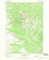
1966 Map of Caribou mtn
USGS Topo · Published 1970About this map
Caribou Mountain dominates this mid-1960s survey of the high country along the border of Bonneville Co and Caribou Co. The landscape is a network of water and early industry, featuring remote operations like the Monte Cristo Mine and Evergreen Mine tucked into the steep drainages of City Creek and Jackknife Creek. While the region is primarily defined by the Caribou National Forest, evidence of earlier settlement remains at Caribou City (Site) and the Gray Cem near the southern edge. The terrain is navigated by a complex system of primitive routes, labeled as either Jeep Trail or Pack Trail, reflecting the difficult access to high-elevation landmarks like Jackknife Basin and Morgan Meadow. This map provides a detailed look at the infrastructure of the Idaho mineral and timber lands before modern development altered these remote drainages.
Find a feature on this map
21 named features on this map. Tap any name to fly to it.
Don’t see what you’re looking for? This feature index may not catch every label — zoom into the map to look around manually.
Map Details
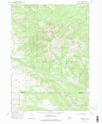
Editions of this 1966 Caribou mtn Map
3 editions found

Other maps of this area

1915 · Freedom
USGS Topo · 1:62,500

1915 · Lanes Creek
USGS Topo · 1:62,500

1932 · Irwin
USGS Topo · 1:96,000

1935 · Irwin
USGS Topo · 1:125,000

1955 · Driggs
USGS Topo · 1:250,000

1955 · Preston
USGS Topo · 1:250,000

1958 · Driggs
USGS Topo · 1:250,000

1958 · Preston
USGS Topo · 1:250,000

1962 · Driggs
USGS Topo · 1:250,000

1962 · Preston
USGS Topo · 1:250,000