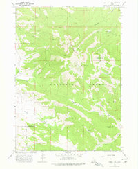
1966 Map of Caribou mtn
USGS Topo · Published 1977About this map
Caribou Mountain dominates the landscape of this mid-1960s survey, straddling the boundary of the Caribou National Forest across the Bonneville and Caribou county lines. The area is defined by its gold mining history, evidenced by the presence of the Monte Cristo Mine, Evergreen Mine, and the noted location of Caribou City (Site) near Iowa Gulch. These sites point to a period of extraction that shaped the local geography alongside grazing and high-altitude meadow use, such as at Morgan Meadow.
Find a feature on this map
24 named features on this map. Tap any name to fly to it.
Don’t see what you’re looking for? This feature index may not catch every label — zoom into the map to look around manually.
Map Details
Editions of this 1966 Caribou mtn Map
3 editions found
Other maps of this area

1915 · Freedom
USGS Topo · 1:62,500

1915 · Lanes Creek
USGS Topo · 1:62,500

1932 · Irwin
USGS Topo · 1:96,000

1935 · Irwin
USGS Topo · 1:125,000

1955 · Driggs
USGS Topo · 1:250,000

1955 · Preston
USGS Topo · 1:250,000

1958 · Driggs
USGS Topo · 1:250,000

1958 · Preston
USGS Topo · 1:250,000

1962 · Driggs
USGS Topo · 1:250,000

1962 · Preston
USGS Topo · 1:250,000