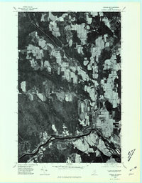
1975 Map of Caribou SW
USGS Topo · Published 1981About this map
Washburn serves as a focal point in this northern Aroostook County landscape, situated where the Salmon Brook meets the sweeping curve of the Aroostook River. This orthophoto map, created from aerial photography taken in May 1975, reveals the precise agricultural patterns and forest boundaries of the era. The imagery clearly shows the concentration of development in settlements like Bugbee and Perham, while the surrounding acreage is defined by a patchwork of cleared farmland and dense woodlots. Tracing the courses of West Branch Salmon Brook and Gardiner Brook, one can see how the hydrology influenced local road placement and field orientation. The small settlement of Carson appears to the northeast, illustrating the decentralized rural community structure common in Maine's potato-growing regions during the mid-1970s.
Find a feature on this map
8 named features on this map. Tap any name to fly to it.
Don’t see what you’re looking for? This feature index may not catch every label — zoom into the map to look around manually.
Map Details
Editions of this 1975 Caribou SW Map
This is the sole edition of this map. No revisions or reprints were ever made.
Other maps of this area

1929 · Portage
USGS Topo · 1:62,500

1929 · Caribou
USGS Topo · 1:48,000

1931 · Ashland
USGS Topo · 1:48,000

1931 · Portage
USGS Topo · 1:62,500

1932 · Caribou
USGS Topo · 1:62,500

1934 · Ashland
USGS Topo · 1:62,500

1935 · Presque Isle
USGS Topo · 1:62,500

1953 · Ashland
USGS Topo · 1:62,500

1953 · Portage
USGS Topo · 1:62,500
1953 · New Sweden
USGS Topo · 1:24,000