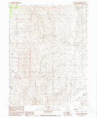
1990 Map of Carico Lake North
USGS Topo · Published 1990About this map
The Shoshone Range dominates this portion of Nevada, with its ridges giving way to the expansive Carico Lake Valley in the southeast. This high-desert landscape is characterized by its intermittent water sources and extreme elevation changes, features that dictated the movement of early travelers and miners. Evidence of human activity is sparse but significant, marked by a single Grave and a remote Prospect, suggesting the isolated nature of frontier life and resource exploration. Water management is the primary driver of the terrain's naming, with Wilson Canyon and Rattlesnake Canyon funneling seasonal runoff toward the arid basin of Carico Lake (Dry). The presence of Granite Spring and several other unnamed springs indicates the vital points of survival in an area otherwise defined by dry creek beds like Moss Creek and Cooks Creek.
Find a feature on this map
17 named features on this map. Tap any name to fly to it.
Don’t see what you’re looking for? This feature index may not catch every label — zoom into the map to look around manually.
Map Details
Editions of this 1990 Carico Lake North Map
This is the sole edition of this map. No revisions or reprints were ever made.
Other maps of this area

1932 · Sonoma Range
USGS Topo · 1:250,000

1939 · Sonoma Range
USGS Topo · 1:250,000

1949 · Mt. Lewis
USGS Topo · 1:62,500

1950 · Mt. Lewis
USGS Topo · 1:62,500

1955 · Winnemucca
USGS Topo · 1:250,000

1958 · Winnemucca
USGS Topo · 1:250,000

1961 · McCoy
USGS Topo · 1:62,500

1961 · The Cedars
USGS Topo · 1:62,500

1962 · Winnemucca
USGS Topo · 1:250,000

1962 · Carico Lake
USGS Topo · 1:62,500