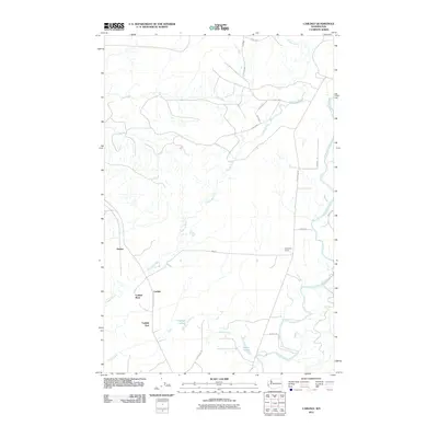
2011 Map of Carlisle
USGS Topo · Published 2011About this map
Carlisle and its surrounding clusters, Carlisle West and Carlisle East, anchor this coastal Washington landscape defined by a complex network of waterways. The Copalis River meanders through the central terrain, eventually meeting the lower reaches of the Humptulips River to the southeast. This geography is marked by small water bodies like the Carlisle Lakes and Damon Lake, which drain into several named tributaries including Damon Creek and Joe Creek. Industrial and transit footprints are evident at the Kirkpatrick Quarry and via thoroughfares such as Ocean Beach Rd and Kirkpatrick Rd. The settlement of Onslow sits to the west, situated within a topography that balances timbered lands and river valleys. The presence of numerous numbered forestry roads suggests the ongoing importance of resource management in this corner of Grays Harbor County during the early 21st century.
Find a feature on this map
24 named features on this map. Tap any name to fly to it.
Don’t see what you’re looking for? This feature index may not catch every label — zoom into the map to look around manually.
Map Details
Editions of this 2011 Carlisle Map
This is the sole edition of this map. No revisions or reprints were ever made.
Other maps of this area
1921 · Quinault Lake
USGS Topo · 1:62,500
1938 · Moclips
USGS Topo · 1:62,500
1941 · Moclips
USGS Topo · 1:62,500
1943 · Humptulips
USGS Topo · 1:62,500
1943 · Copalis Beach
USGS Topo · 1:250,000
1951 · Copalis Beach
USGS Topo · 1:250,000
1955 · Macafee Hill
USGS Topo · 1:62,500
1955 · Humptulips
USGS Topo · 1:62,500
1955 · Quinault Lake
USGS Topo · 1:62,500
1955 · Carlisle
USGS Topo · 1:24,000