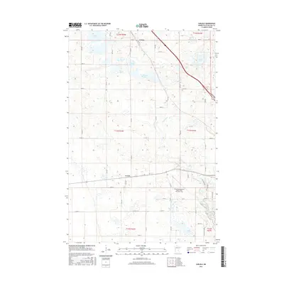
2016 Map of Carlisle
USGS Topo · Published 2016About this map
Carlisle and French anchor this landscape in Otter Tail County, where the transition from prairie to wetlands is marked by a complex network of glacial lakes and river systems. The Pelican River meanders through the central terrain, eventually joining the Otter Tail River in the south, which feeds into the Dayton Hollow Reservoir. This area is defined by its numerous water bodies, ranging from the large Lake Oscar and Johnson Lake to smaller basins like Wedel Lake and Rush Lake. To the south, the Fergus Falls Municipal Airport-Einar Mickelson Field provides a modern logistical hub amidst the rural section lines. The drainage patterns of the Skogen Marsh and surrounding wetlands reflect the agricultural character of the region, where a grid of rural roads like Co HWY 11 and Old Hwy 52 connects small settlements to the river-driven economy of the Minnesota interior.
Find a feature on this map
38 named features on this map. Tap any name to fly to it.
Don’t see what you’re looking for? This feature index may not catch every label — zoom into the map to look around manually.
Map Details
Editions of this 2016 Carlisle Map
This is the sole edition of this map. No revisions or reprints were ever made.
Other maps of this area

1910 · Wendell
USGS Topo · 1:62,500

1913 · Fergus Falls
USGS Topo · 1:62,500

1913 · Wendell
USGS Topo · 1:62,500

1919 · Rothsay
USGS Topo · 1:62,500

1951 · Rothsay
USGS Topo · 1:62,500

1951 · Campbell
USGS Topo · 1:62,500

1953 · Fargo
USGS Topo · 1:250,000

1956 · Fargo
USGS Topo · 1:250,000

1966 · Carlisle
USGS Topo · 1:24,000
1973 · Dayton Hollow Dam
USGS Topo · 1:24,000