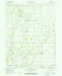
1960 Map of Carlos
USGS Topo · Published 1984About this map
The Old Indian Treaty Boundary slices diagonally across this agricultural landscape in southern Randolph County, marking a historic line that still influences modern property boundaries and road alignments. Small rural hubs like Carlos, Modoc, and Huntsville serve as focal points for the surrounding farmsteads, connected by the New York Central railroad corridor. The terrain is defined by a dense network of minor waterways, including Martindale Creek, Cabin Run, and Sugar Creek, which drain toward the White River and Stoney Creek. Local community life is anchored by traditional landmarks such as Salem Cem, Union Ch, and Martindale Ch. The map captures a moment of established rural stability, where the land use is primarily defined by large-scale farming and the infrastructure of the railroad era, just before the significant shifts in mid-century transportation patterns.
Find a feature on this map
44 named features on this map. Tap any name to fly to it.
Don’t see what you’re looking for? This feature index may not catch every label — zoom into the map to look around manually.
Map Details
Editions of this 1960 Carlos Map
3 editions found

Other maps of this area

1915 · New Paris
USGS Topo · 1:48,000

1916 · Winchester
USGS Topo · 1:48,000

1918 · Winchester
USGS Topo · 1:62,500

1918 · New Paris
USGS Topo · 1:62,500

1943 · Winchester
USGS Topo · 1:62,500

1952 · Maxville
USGS Topo · 1:24,000

1952 · Farmland
USGS Topo · 1:24,000

1953 · Cincinnati
USGS Topo · 1:250,000

1953 · Muncie
USGS Topo · 1:250,000

1956 · Muncie
USGS Topo · 1:250,000