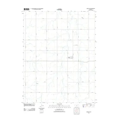
2012 Map of Carlton
USGS Topo · Published 2012About this map
Carlton serves as the central hub of this agricultural landscape in Dickinson County, defined by a rigid grid of rural roads and the winding paths of several regional waterways. The town's layout, centered around Main Ave and N 7th St, reflects a classic Kansas prairie settlement pattern where the geometry of human transit meets the natural meanders of Holland Cr. Genealogists and local historians can locate burial sites at Fairview Cem in the northeast and Woodlawn Cem to the southwest, providing key points for family research. The terrain is deeply etched by the drainage systems of W Holland Cr and E Holland Cr, which converge as they move through the township. This 2012 survey illustrates the enduring rural character of the region, where named routes like Daisy Rd and Deer Rd connect isolated homesteads to the village core.
Find a feature on this map
28 named features on this map. Tap any name to fly to it.
Don’t see what you’re looking for? This feature index may not catch every label — zoom into the map to look around manually.
Map Details
Editions of this 2012 Carlton Map
This is the sole edition of this map. No revisions or reprints were ever made.
Other maps of this area

1889 · Abilene
USGS Topo · 1:125,000

1894 · Abilene
USGS Topo · 1:125,000

1955 · Kipp
USGS Topo · 1:24,000

1955 · Gypsum
USGS Topo · 1:24,000

1955 · Hutchinson
USGS Topo · 1:250,000

1959 · Hutchinson
USGS Topo · 1:250,000

1963 · Abilene SW
USGS Topo · 1:24,000
1963 · Holland
USGS Topo · 1:24,000

1964 · Elmo
USGS Topo · 1:24,000

1964 · Carlton
USGS Topo · 1:24,000