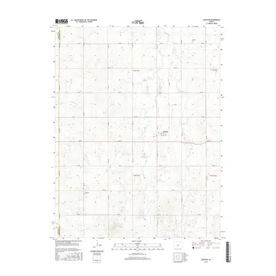
2015 Map of Carlton
USGS Topo · Published 2015About this map
Carlton stands as the central hub of this agricultural landscape in Dickinson County, defined by a rigid grid of rural section roads. The settlement is anchored by Main Ave and Peck Ave, illustrating a classic Kansas township layout where the community grew around key transportation crossings. The terrain is deeply etched by the drainage networks of W Holland Cr and E Holland Cr, which create a rolling relief against the straight lines of the surrounding road system.
Find a feature on this map
31 named features on this map. Tap any name to fly to it.
Don’t see what you’re looking for? This feature index may not catch every label — zoom into the map to look around manually.
Map Details
Editions of this 2015 Carlton Map
This is the sole edition of this map. No revisions or reprints were ever made.
Other maps of this area

1889 · Abilene
USGS Topo · 1:125,000

1894 · Abilene
USGS Topo · 1:125,000

1955 · Kipp
USGS Topo · 1:24,000

1955 · Gypsum
USGS Topo · 1:24,000

1955 · Hutchinson
USGS Topo · 1:250,000

1959 · Hutchinson
USGS Topo · 1:250,000

1963 · Abilene SW
USGS Topo · 1:24,000
1963 · Holland
USGS Topo · 1:24,000

1964 · Elmo
USGS Topo · 1:24,000

1964 · Carlton
USGS Topo · 1:24,000