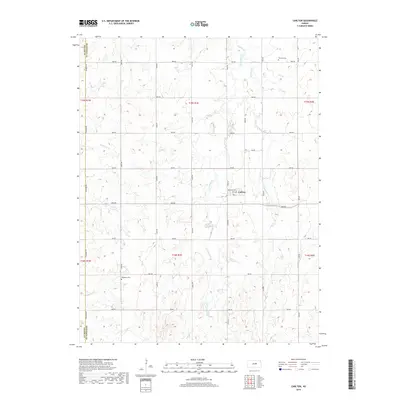
2018 Map of Carlton
USGS Topo · Published 2018About this map
Holland Cr and its tributaries, including W Holland Cr and E Holland Cr, carve a complex drainage pattern through this section of the Kansas plains. The small community of Carlton serves as the primary settlement, situated near the intersection of Kentucky Ave and Peck Ave. The landscape is defined by a rigid grid of rural roads such as Camp Rd, Daisy Rd, and Solomon Rd, the latter of which follows the boundary between Dickinson Co and Saline Co.
Find a feature on this map
33 named features on this map. Tap any name to fly to it.
Don’t see what you’re looking for? This feature index may not catch every label — zoom into the map to look around manually.
Map Details
Editions of this 2018 Carlton Map
This is the sole edition of this map. No revisions or reprints were ever made.
Other maps of this area

1889 · Abilene
USGS Topo · 1:125,000

1894 · Abilene
USGS Topo · 1:125,000

1955 · Kipp
USGS Topo · 1:24,000

1955 · Gypsum
USGS Topo · 1:24,000

1955 · Hutchinson
USGS Topo · 1:250,000

1959 · Hutchinson
USGS Topo · 1:250,000

1963 · Abilene SW
USGS Topo · 1:24,000
1963 · Holland
USGS Topo · 1:24,000

1964 · Elmo
USGS Topo · 1:24,000

1964 · Carlton
USGS Topo · 1:24,000