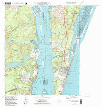
1997 Map of Carolina Beach
USGS Topo · Published 1999About this map
Orton Plantation and the historic Brunswick Town ruins anchor the western bank of the Cape Fear River, where the landscape transitions from coastal wetlands to significant cultural sites. Across the water, the barrier island development is dense at Carolina Beach and Kure Beach, bisected by the engineering of Snows Cut and the protected waters of Myrtle Sound. The presence of the Military Ocean Terminal Sunny Point and its dedicated Military Ocean Terminal Sunny Point Railroad illustrates the strategic shipping and logistics infrastructure required for this deep-water corridor.
Find a feature on this map
62 named features on this map. Tap any name to fly to it.
Don’t see what you’re looking for? This feature index may not catch every label — zoom into the map to look around manually.
Map Details
Editions of this 1997 Carolina Beach Map
This is the sole edition of this map. No revisions or reprints were ever made.
Other maps of this area

1942 · Wilmington
USGS Topo · 1:62,500

1943 · Funston
USGS Topo · 1:24,000

1943 · Winnabow
USGS Topo · 1:24,000

1944 · Winnabow
USGS Topo · 1:31,680

1946 · Southport
USGS Topo · 1:24,000

1946 · Snow Marsh
USGS Topo · 1:24,000

1948 · Wilmington
USGS Topo · 1:62,500

1949 · Georgetown
USGS Topo · 1:250,000

1950 · Winnabow
USGS Topo · 1:25,000

1953 · Florence
USGS Topo · 1:250,000