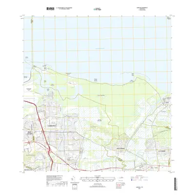
2018 Map of Carolina
USGS Topo · Published 2018About this map
Carolina and the eastern edge of San Juan dominate this 2018 coastal survey, where the urban grid meets the intricate lagoons and wetlands of the Island of Puerto Rico. The landscape is defined by the massive infrastructure of the Luis Munoz Marin International Airport and a series of prominent coastal points including Punta Maldonado and Punta Vacía Talega. Significant residential and industrial expansion is evident around Santa Bárbara and San Isidro, yet the region maintains its connection to the sea through Aviones Beach and Playa Torrecillas Pinones. The Rio Grande De Loiza and Rio Canóvanas snake through the lowlands, bordered by numerous caños like Caño Zequeira and Caño Palúdica. Local heritage is anchored by sites such as the Cementerio Municipal de Carolina and the inland hills of Los Cerros del Comandante, illustrating the balance between modern metropolitan growth and the island's natural hydrological systems.
Find a feature on this map
53 named features on this map. Tap any name to fly to it.
Don’t see what you’re looking for? This feature index may not catch every label — zoom into the map to look around manually.
Map Details
Editions of this 2018 Carolina Map
This is the sole edition of this map. No revisions or reprints were ever made.
Other maps of this area

1940 · Carolina
USGS Topo · 1:30,000

1941 · San Juan
USGS Topo · 1:30,000

1941 · Rio Grande
USGS Topo · 1:30,000

1941 · Carolina
USGS Topo · 1:30,000

1945 · El Yunque
USGS Topo · 1:30,000

1946 · El Yunque
USGS Topo · 1:30,000

1946 · Aguas Buenas
USGS Topo · 1:30,000

1946 · Gurabo
USGS Topo · 1:30,000

1947 · Carolina
USGS Topo · 1:30,000

1947 · Gurabo NE
USGS Topo · 1:10,000