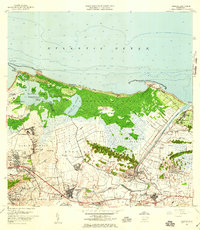
1957 Map of Carolina
USGS Topo · Published 1959About this map
The Rio Grande de Loiza winds through a landscape of coastal lagoons and industrial growth in this mid-century survey of northeastern Puerto Rico. The sugar industry remains a dominant force with the Central Canovanas and Central Victoria mills anchoring the local economy. At the same time, the transition toward modern infrastructure is evident in the presence of the Aeropuerto Internacional and the Hipodromo El Comandante racing facility near El Comandante.
Find a feature on this map
72 named features on this map. Tap any name to fly to it.
Don’t see what you’re looking for? This feature index may not catch every label — zoom into the map to look around manually.
Map Details
Editions of this 1957 Carolina Map
This is the sole edition of this map. No revisions or reprints were ever made.
Other maps of this area

1940 · Carolina
USGS Topo · 1:30,000

1941 · San Juan
USGS Topo · 1:30,000

1941 · Rio Grande
USGS Topo · 1:30,000

1941 · Carolina
USGS Topo · 1:30,000

1945 · El Yunque
USGS Topo · 1:30,000

1946 · El Yunque
USGS Topo · 1:30,000

1946 · Aguas Buenas
USGS Topo · 1:30,000

1946 · Gurabo
USGS Topo · 1:30,000

1947 · Carolina
USGS Topo · 1:30,000

1947 · Gurabo NE
USGS Topo · 1:10,000