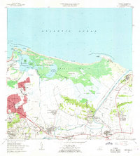
1963 Map of Carolina
USGS Topo · Published 1965About this map
Rio Grande de Loiza snakes through the eastern landscape of this coastal survey, defining the boundaries and agricultural patterns of the early 1960s. The northern coast is characterized by a dense network of mangroves and wetlands, protected within the Bosque Estatal de Piñones and surrounding the Laguna de Piñones. This era shows a significant intersection of traditional settlements and emerging urban infrastructure, with the Hipodromo El Comandante and the Aeropuerto Internacional de Isla Verde standing as major regional landmarks. Inland, the transition from the concentrated residential blocks of Carolina and Villa Carolina to the more rural, plantation-influenced barrios of Hoyo Mulas and Torrecilla Alta is clearly visible. The presence of numerous small schools like Escuela Amalia Expósito and local industrial features like the Cantera quarry sites highlight the community-scale development typical of the period.
Find a feature on this map
100 named features on this map. Tap any name to fly to it.
Don’t see what you’re looking for? This feature index may not catch every label — zoom into the map to look around manually.
Map Details
Editions of this 1963 Carolina Map
This is the sole edition of this map. No revisions or reprints were ever made.
Other maps of this area

1940 · Carolina
USGS Topo · 1:30,000

1941 · San Juan
USGS Topo · 1:30,000

1941 · Rio Grande
USGS Topo · 1:30,000

1941 · Carolina
USGS Topo · 1:30,000

1945 · El Yunque
USGS Topo · 1:30,000

1946 · El Yunque
USGS Topo · 1:30,000

1946 · Aguas Buenas
USGS Topo · 1:30,000

1946 · Gurabo
USGS Topo · 1:30,000

1947 · Carolina
USGS Topo · 1:30,000

1947 · Gurabo NE
USGS Topo · 1:10,000