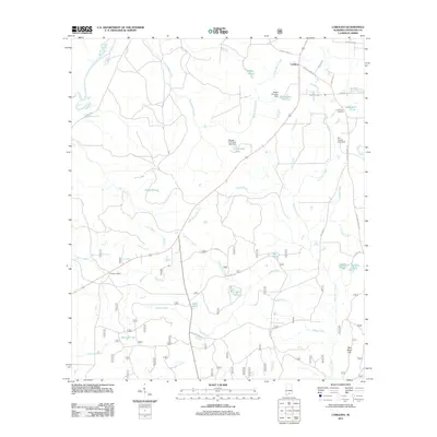
2011 Map of Carolina
USGS Topo · Published 2011About this map
Carolina and Pleasant Home anchor this rural Covington County landscape, where the hydrography is defined by a dense network of named ponds and creeks feeding toward the Conecuh River. The mapping shows a high concentration of small, localized water bodies such as Nellie Ponds, Mossy Ponds, and Indigo Ponds, reflecting a terrain of low-lying wetlands and intermittent drainage. Significant local landmarks include the Robert Brantley Dam, which impounds Brantwood Pond, and the George W Proctor Lake Dam at Dogwood Lake.
Find a feature on this map
39 named features on this map. Tap any name to fly to it.
Don’t see what you’re looking for? This feature index may not catch every label — zoom into the map to look around manually.
Map Details
Editions of this 2011 Carolina Map
This is the sole edition of this map. No revisions or reprints were ever made.
Other maps of this area

1953 · Andalusia
USGS Topo · 1:250,000

1957 · Andalusia
USGS Topo · 1:250,000

1971 · Dixie
USGS Topo · 1:24,000

1971 · Bradley
USGS Topo · 1:24,000

1971 · Carolina
USGS Topo · 1:24,000

1971 · Libertyville
USGS Topo · 1:24,000

1971 · Wing
USGS Topo · 1:24,000

1971 · River Falls
USGS Topo · 1:24,000

1971 · Andalusia
USGS Topo · 1:24,000
1971 · Watkins Bridge
USGS Topo · 1:24,000