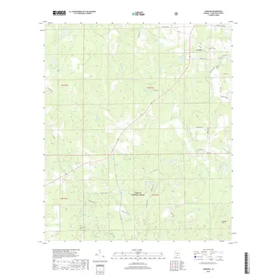
2018 Map of Carolina
USGS Topo · Published 2018About this map
The small community of Carolina anchors the northeastern portion of this survey, surrounded by family-named landmarks and rural farm roads. The landscape is defined by the heavy timber of the Conecuh National Forest, where the Conecuh Trail winds through a complex system of hydrology including Panther Cr, Teel Cr, and the Conecuh River. This geography reflects a modern era of forest management and outdoor recreation, while retaining traces of local genealogy at the Carolina Cem and on agricultural holdings like Mauldin Farm Ln and Wiggins Farm Rd. Numerous distinct water bodies, from Dogwood Lake to Indigo Ponds, emphasize the low-lying, poorly drained nature of this Covington County terrain. The transition from the high point at Red Wash Hill down to the river bottoms illustrates the natural topography that has shaped settlement patterns here for generations.
Find a feature on this map
56 named features on this map. Tap any name to fly to it.
Don’t see what you’re looking for? This feature index may not catch every label — zoom into the map to look around manually.
Map Details
Editions of this 2018 Carolina Map
This is the sole edition of this map. No revisions or reprints were ever made.
Other maps of this area

1953 · Andalusia
USGS Topo · 1:250,000

1957 · Andalusia
USGS Topo · 1:250,000

1971 · Dixie
USGS Topo · 1:24,000

1971 · Bradley
USGS Topo · 1:24,000

1971 · Carolina
USGS Topo · 1:24,000

1971 · Libertyville
USGS Topo · 1:24,000

1971 · Wing
USGS Topo · 1:24,000

1971 · River Falls
USGS Topo · 1:24,000

1971 · Andalusia
USGS Topo · 1:24,000
1971 · Watkins Bridge
USGS Topo · 1:24,000