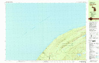
1980 Map of Carp River
USGS Topo · Published 1981About this map
Porcupine Mountains Wilderness State Park dominates this 1980 survey, showing the preserved landscape of the Porcupine Mountains along the shores of Lake Superior. The map details a network of backcountry paths including the Superior Trail and Lake Trail, which connect inland waters like Lake of the Clouds and Mirror Lake to the rocky coast. Evidence of the region’s industrial past is found at the Old LaFayette Mine near LaFayette Peak, marking where early copper exploration once took place within these highlands.
Find a feature on this map
33 named features on this map. Tap any name to fly to it.
Don’t see what you’re looking for? This feature index may not catch every label — zoom into the map to look around manually.
Map Details
Editions of this 1980 Carp River Map
2 editions found
Other maps of this area

1953 · Ashland
USGS Topo · 1:250,000

1956 · Carp River
USGS Topo · 1:62,500

1956 · North Ironwood
USGS Topo · 1:62,500

1956 · Bergland
USGS Topo · 1:62,500

1956 · Thomaston
USGS Topo · 1:62,500

1956 · White Pine
USGS Topo · 1:62,500

1958 · Ashland
USGS Topo · 1:250,000

1958 · Iron River
USGS Topo · 1:250,000

1960 · Iron River
USGS Topo · 1:250,000

1961 · Iron River
USGS Topo · 1:250,000