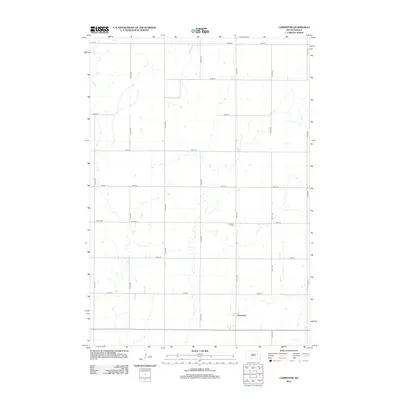
2012 Map of Carpenter
USGS Topo · Published 2012About this map
Carpenter serves as the primary community anchor in this rural portion of Spink County, centered around a Po and the intersection of section-line roads. The landscape is defined by the wandering path of Foster Cr, which meanders through the western and central portions of the quadrangle, punctuated by numerous small depressions and seasonal wetlands typical of the Dakota prairie. Land use is dominated by a strict grid of agricultural roads, including 182 St and 414th Ave, which organize the territory into distinct sections. For those researching local family histories, the map identifies two significant burial sites: Union Cem in the west and Richland Cem further east. The arrangement of these features reflects a late-twentieth-century rural economy where small-town centers like Carpenter remained vital hubs for the surrounding farmsteads.
Find a feature on this map
23 named features on this map. Tap any name to fly to it.
Don’t see what you’re looking for? This feature index may not catch every label — zoom into the map to look around manually.
Map Details
Editions of this 2012 Carpenter Map
This is the sole edition of this map. No revisions or reprints were ever made.
Other maps of this area

1895 · Byron
USGS Topo · 1:125,000

1953 · Huron
USGS Topo · 1:250,000

1953 · Watertown
USGS Topo · 1:250,000

1954 · Huron
USGS Topo · 1:250,000

1956 · Lake Byron SE
USGS Topo · 1:24,000

1958 · Watertown
USGS Topo · 1:250,000
1971 · Doland SE
USGS Topo · 1:24,000
1971 · Bloomfield
USGS Topo · 1:25,000
1973 · Staum Dam
USGS Topo · 1:24,000

1973 · Carpenter SE
USGS Topo · 1:24,000