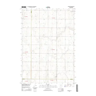
2015 Map of Carpenter
USGS Topo · Published 2015About this map
Carpenter sits at the southern edge of this landscape where the boundaries of Spink, Clark, and Beadle counties converge. The terrain is defined by the Coteau des Prairies, a vast plateau that shapes the drainage and elevation of this agricultural region. The map reveals a strictly organized section line road system, including routes like 182nd St and CR-45, which partition the land into the traditional township and range grid. Local heritage is anchored by two established burial grounds, Union Cem to the west and Richland Cem further east, serving as the primary genealogical markers for the rural families who settled these sections. This survey provides a clear view of the high-plains geography before modern expansion, focused on the intersection of rural life and the physical limits of the plateau.
Find a feature on this map
22 named features on this map. Tap any name to fly to it.
Don’t see what you’re looking for? This feature index may not catch every label — zoom into the map to look around manually.
Map Details
Editions of this 2015 Carpenter Map
This is the sole edition of this map. No revisions or reprints were ever made.
Other maps of this area

1895 · Byron
USGS Topo · 1:125,000

1953 · Huron
USGS Topo · 1:250,000

1953 · Watertown
USGS Topo · 1:250,000

1954 · Huron
USGS Topo · 1:250,000

1956 · Lake Byron SE
USGS Topo · 1:24,000

1958 · Watertown
USGS Topo · 1:250,000
1971 · Doland SE
USGS Topo · 1:24,000
1971 · Bloomfield
USGS Topo · 1:25,000
1973 · Staum Dam
USGS Topo · 1:24,000

1973 · Carpenter SE
USGS Topo · 1:24,000