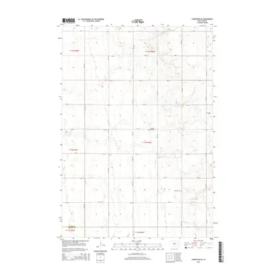
2015 Map of Carpenter NE
USGS Topo · Published 2015About this map
The Coteau des Prairies plateau dominates this section of the South Dakota landscape, characterized by its complex glacial topography and numerous small depressions. In this rural environment along the border of Clark and Beadle counties, the land is organized by a strict grid of section lines and local roads like CR-45. This 2015 survey reveals how the natural hydrology of the plains, represented by the meandering paths of Shue Cr, Pearl Cr, and Redstone Cr, interacts with human agricultural patterns. For genealogists and local historians, the map serves as a precise record of local landmarks, specifically identifying the locations of Woodland Cem and Hague Cem, which stand as quiet markers of the area's rural community heritage.
Find a feature on this map
27 named features on this map. Tap any name to fly to it.
Don’t see what you’re looking for? This feature index may not catch every label — zoom into the map to look around manually.
Map Details
Editions of this 2015 Carpenter NE Map
This is the sole edition of this map. No revisions or reprints were ever made.
Other maps of this area

1953 · Watertown
USGS Topo · 1:250,000

1958 · Watertown
USGS Topo · 1:250,000
1973 · Staum Dam
USGS Topo · 1:24,000

1973 · Carpenter SE
USGS Topo · 1:24,000

1973 · Willow Lake
USGS Topo · 1:24,000

1973 · Clark South
USGS Topo · 1:24,000
1973 · Carpenter
USGS Topo · 1:24,000
1973 · Willow Lake SW
USGS Topo · 1:24,000
1973 · Raymond SE
USGS Topo · 1:24,000
1973 · Carpenter NE
USGS Topo · 1:24,000