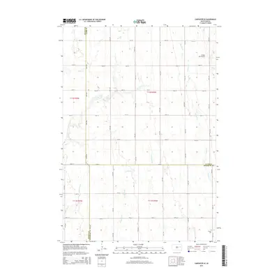
2015 Map of Carpenter SE
USGS Topo · Published 2015About this map
The Coteau des Prairies plateau defines the eastern terrain of this 2015 survey, where the rolling heights of this geological feature meet the headwaters of several prairie streams. The landscape is dominated by a systematic grid of section roads, including 191st ST and 418th Ave, which crisscross the agricultural land. Waterways like Redstone Cr and the various branches of Pearl Creek, including S Fork Pearl Cr and Middle Pearl Cr, wind through the township, influencing the placement of local homesteads. Genealogists and local historians will find the LeSueur Cem in the southeastern corner, a primary landmark in a region defined by its rural character and the intersection of Beadle, Clark, and Kingsbury counties.
Find a feature on this map
29 named features on this map. Tap any name to fly to it.
Don’t see what you’re looking for? This feature index may not catch every label — zoom into the map to look around manually.
Map Details
Editions of this 2015 Carpenter SE Map
This is the sole edition of this map. No revisions or reprints were ever made.
Other maps of this area

1899 · De Smet
USGS Topo · 1:125,000

1953 · Watertown
USGS Topo · 1:250,000

1958 · Watertown
USGS Topo · 1:250,000

1971 · Bancroft East
USGS Topo · 1:24,000

1971 · Bancroft West
USGS Topo · 1:24,000
1971 · Yale
USGS Topo · 1:24,000
1973 · Staum Dam
USGS Topo · 1:24,000

1973 · Carpenter SE
USGS Topo · 1:24,000

1973 · Willow Lake
USGS Topo · 1:24,000
1973 · Carpenter
USGS Topo · 1:24,000