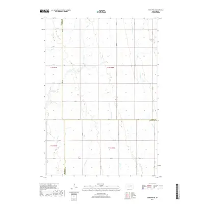
2017 Map of Carpenter SE
USGS Topo · Published 2017About this map
The Coteau des Prairies plateau dominates the eastern landscape of this Kingsbury and Beadle County boundary region, where a complex network of prairie streams drains the glacial terrain. In the southeast, the LeSueur Cem serves as a significant genealogical marker for the rural community in Le Sueur Township. The hydrology is particularly intricate here, with several branches of Pearl Cr, including Middle Pearl Cr and the S Fork Pearl Cr, cutting across the township lines. These waterways, along with Redstone Cr and Shue Cr, define the natural drainage patterns of this agricultural area. The map illustrates a rigid section-line road grid, including Co RD 8 and Co RD 56, which facilitated the late-twentieth and early-twenty-first-century farming economy across this high plains environment.
Find a feature on this map
27 named features on this map. Tap any name to fly to it.
Don’t see what you’re looking for? This feature index may not catch every label — zoom into the map to look around manually.
Map Details
Editions of this 2017 Carpenter SE Map
This is the sole edition of this map. No revisions or reprints were ever made.
Other maps of this area

1899 · De Smet
USGS Topo · 1:125,000

1953 · Watertown
USGS Topo · 1:250,000

1958 · Watertown
USGS Topo · 1:250,000

1971 · Bancroft East
USGS Topo · 1:24,000

1971 · Bancroft West
USGS Topo · 1:24,000
1971 · Yale
USGS Topo · 1:24,000
1973 · Staum Dam
USGS Topo · 1:24,000

1973 · Carpenter SE
USGS Topo · 1:24,000

1973 · Willow Lake
USGS Topo · 1:24,000
1973 · Carpenter
USGS Topo · 1:24,000